'%20stroke-width='2.5'%20stroke-miterlimit='10'/%3e%3cpath%20d='M5.54395%2029.0272C5.54395%2029.0272%207.21042%2028.2954%208.61046%2028.9609C10.0105%2029.6257%2012.677%2031.5545%2014.2106%2031.4213C15.7443%2031.288%2021.1445%2028.2292%2024.011%2028.8939C26.8775%2029.5587%2028.7447%2031.687%2030.9448%2031.687C33.1448%2031.687%2038.4114%2028.8939%2039.9451%2029.3592C41.4787%2029.8245%2042.2116%2030.091%2042.2116%2030.091'%20stroke='url(%23paint1_linear_283_2521)'%20stroke-width='2.5'%20stroke-miterlimit='10'/%3e%3cpath%20d='M8.4502%2035.0447C8.4502%2035.0447%2011.9696%2037.3236%2014.8096%2037.1392C17.6497%2036.9547%2020.7374%2034.4289%2023.145%2034.8603C25.5534%2035.2917%2029.752%2037.755%2031.6661%2037.755C33.5801%2037.755%2037.8406%2036.2154%2037.8406%2036.2154'%20stroke='url(%23paint2_linear_283_2521)'%20stroke-width='2.5'%20stroke-miterlimit='10'/%3e%3cpath%20d='M23.5075%2042.8519C33.8158%2042.8519%2042.1723%2034.5162%2042.1723%2024.2337C42.1723%2013.9511%2033.8158%205.61548%2023.5075%205.61548C13.1993%205.61548%204.84277%2013.9511%204.84277%2024.2337C4.84277%2034.5162%2013.1993%2042.8519%2023.5075%2042.8519Z'%20stroke='url(%23paint3_linear_283_2521)'%20stroke-width='2.5'%20stroke-miterlimit='10'/%3e%3cpath%20d='M23.8328%209.86022C23.8629%209.90539%2026.5408%2013.1916%2026.577%2014.9382C26.6283%2017.4054%2024.9158%2018.2696%2023.5082%2018.2877C22.2342%2018.3043%2020.5474%2016.7752%2020.8364%2014.884C21.0447%2013.5214%2023.4358%209.26546%2023.8335%209.85947L23.8328%209.86022Z'%20fill='url(%23paint4_linear_283_2521)'/%3e%3cdefs%3e%3clinearGradient%20id='paint0_linear_283_2521'%20x1='0.703292'%20y1='24.3863'%20x2='60.8739'%20y2='24.3863'%20gradientUnits='userSpaceOnUse'%3e%3cstop%20stop-color='%23BFD5E3'/%3e%3cstop%20offset='0.47'%20stop-color='%237F99AE'/%3e%3cstop%20offset='1'%20stop-color='%23355262'/%3e%3c/linearGradient%3e%3clinearGradient%20id='paint1_linear_283_2521'%20x1='1.68278'%20y1='30.1842'%20x2='60.1528'%20y2='30.1842'%20gradientUnits='userSpaceOnUse'%3e%3cstop%20stop-color='%23BFD5E3'/%3e%3cstop%20offset='0.47'%20stop-color='%237F99AE'/%3e%3cstop%20offset='1'%20stop-color='%23355262'/%3e%3c/linearGradient%3e%3clinearGradient%20id='paint2_linear_283_2521'%20x1='5.35533'%20y1='36.2829'%20x2='52.2211'%20y2='36.2829'%20gradientUnits='userSpaceOnUse'%3e%3cstop%20stop-color='%23BFD5E3'/%3e%3cstop%20offset='0.47'%20stop-color='%237F99AE'/%3e%3cstop%20offset='1'%20stop-color='%23355262'/%3e%3c/linearGradient%3e%3clinearGradient%20id='paint3_linear_283_2521'%20x1='0.911906'%20y1='24.2334'%20x2='60.4374'%20y2='24.2334'%20gradientUnits='userSpaceOnUse'%3e%3cstop%20stop-color='%23BFD5E3'/%3e%3cstop%20offset='0.47'%20stop-color='%237F99AE'/%3e%3cstop%20offset='1'%20stop-color='%23355262'/%3e%3c/linearGradient%3e%3clinearGradient%20id='paint4_linear_283_2521'%20x1='20.1957'%20y1='14.0454'%20x2='29.4035'%20y2='14.0454'%20gradientUnits='userSpaceOnUse'%3e%3cstop%20stop-color='%23BFD5E3'/%3e%3cstop%20offset='0.47'%20stop-color='%237F99AE'/%3e%3cstop%20offset='1'%20stop-color='%23355262'/%3e%3c/linearGradient%3e%3c/defs%3e%3c/svg%3e)
AquaTrack
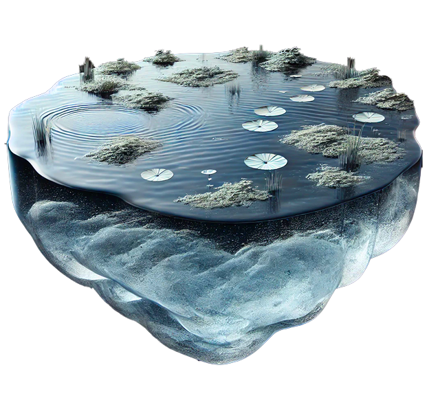
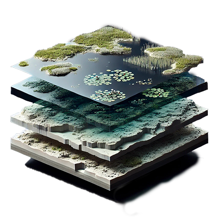
AquaTrack, monitor water surface and storage accurately today, while forecasting tomorrow's trends for smarter water management.
Stay up to date with the news
Upgrade to Aquatrack Premium
Start your 30-day AquaTrack Premium trial and experience the full potential of satellite-based water monitoring. Keep your existing workspace and upgrade to Premium anytime to enjoy unlimited access, proactive alerts, and dedicated support.
Free
3D visualization of bathymetry
Historical data exploration
Export of analysis results
Premium
Predictive monitoring
Subsurface modeling
High-frequency monitoring
Real-time alerts & notifications
Priority support
API access
Need assistance ?
Our support team is here to help! If you have any questions, encounter an issue, or need guidance on using the platform, feel free to reach out.
Get started in a few clicks
Access User Guide